![]() CARIS HPD Paper Chart Editor
CARIS HPD Paper Chart Editor
![]() CARIS Paper Chart Composer
CARIS Paper Chart Composer
Menu | File > Export > Panel > DXF |
Export a panel to a DXF (AutoCAD) file.
A specific area can be exported using the Chart Area command.
Related commands:
• • • • • | • • • • |
Interface
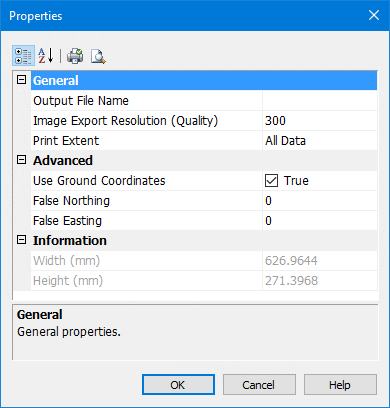
Properties | Description |
|---|---|
Output File Name | The name of the exported DXF file. 1. Click Browse to open the Save As dialog box. 2. Select a path and enter a name for the file. 3. Click Save. The path and name are listed in the dialog box. |
Image Export Resolution | Resolution for images associated with the panel. This option is only for images and not the file. Type a resolution value. |
Print Extent | Panel area to be printed. Select All Data to export the entire panel, or select Export Area if you set an area of the panel for export. |
Use Ground Coordinates | Set the file in ground coordinates instead of geographic coordinates. If this option is selected, the False Northing and False Easting fields are displayed. Select the check box to switch the Ground Coordinates label to True. |
False Northing | Value used to create a false northing. Type the value in the field. |
False Easting | Value used to create a false easting. Type the value in the field. |
Width/Height | Width and height of the area at map scale (read-only). |
Procedure
1. In the Layers window, select a Panel data layer.
2. Select the Export Panel to DXF command.
The Properties dialog box is displayed.
3. Complete the options in the dialog box (see above) and click OK.
A progress bar appears.
To cancel the export at any time, select the Esc key and confirm your action by clicking Yes in the pop-up window.